


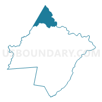
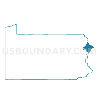
LACKAWAXEN TWP PCT NORTH, Pike County, Pennsylvania
About
Outline

Summary
| Unique Area Identifier | 663669 |
| Name | LACKAWAXEN TWP PCT NORTH |
| County | Pike County |
| State | Pennsylvania |
| Area (square miles) | 37.19 |
| Land Area (square miles) | 35.17 |
| Water Area (square miles) | 2.02 |
| % of Land Area | 94.58 |
| % of Water Area | 5.42 |
| Latitude of the Internal Point | 41.52253430 |
| Longtitude of the Internal Point | -75.07116520 |
Maps

Graphs
Select a template below for downloading or customizing gragh for LACKAWAXEN TWP PCT NORTH, Pike County, Pennsylvania


Neighbors
Neighoring Voting District (by Name) Neighboring Voting District on the Map
- Voting District 080001 080002, Sullivan County, NY
- Voting District 150001, Sullivan County, NY
- BERLIN TWP VTD 01, Wayne County, PA
- BERLIN TWP VTD 02, Wayne County, PA
- LACKAWAXEN TWP PCT SOUTH, Pike County, PA
- PALMYRA TWP Voting District, Wayne County, PA
Top 10 Neighboring County Subdivision (by Population) Neighboring County Subdivision on the Map
- Lackawaxen township, Pike County, PA (4,994)
- Berlin township, Wayne County, PA (2,578)
- Highland town, Sullivan County, NY (2,530)
- Tusten town, Sullivan County, NY (1,515)
- Palmyra township, Wayne County, PA (1,339)
Top 10 Neighboring Place (by Population) Neighboring Place on the Map
Top 10 Neighboring Unified School District (by Population) Neighboring Unified School District on the Map
- Wallenpaupack Area School District, PA (25,535)
- Wayne Highlands School District, PA (20,842)
- Sullivan West Central School District, NY (10,576)
- Eldred Central School District, NY (5,156)
Top 10 Neighboring State Legislative District Lower Chamber (by Population) Neighboring State Legislative District Lower Chamber on the Map
Top 10 Neighboring State Legislative District Upper Chamber (by Population) Neighboring State Legislative District Upper Chamber on the Map
Top 10 Neighboring 111th Congressional District (by Population) Neighboring 111th Congressional District on the Map
Top 10 Neighboring Census Tract (by Population) Neighboring Census Tract on the Map
- Census Tract 9606, Wayne County, PA (5,128)
- Census Tract 9502.01, Pike County, PA (3,497)
- Census Tract 9524, Sullivan County, NY (2,530)
- Census Tract 9523, Sullivan County, NY (1,515)
- Census Tract 9502.02, Pike County, PA (1,497)
Top 10 Neighboring 5-Digit ZIP Code Tabulation Area (by Population) Neighboring 5-Digit ZIP Code Tabulation Area on the Map
- 18428, PA (12,012)
- 18405, PA (2,561)
- 12764, NY (1,802)
- 12719, NY (1,207)
- 18435, PA (795)
- 18457, PA (82)